
Asia is a large continent with several interlinking rivers all over its landmass. These rivers have always played a crucial role in the development of human civilization. The rushing water brings with it the elements to grow crops. Furthermore, it also provides clean drinking water. Even now, rivers offer good land to farm, transportation, and energy, thus making the surrounding area attractive to live in. The Yangtze River is the lengthiest river in the Asian subcontinent. It flows through 10 provinces and has 8 primary tributaries. In this article, we learn about the Yangtze river in detail.
The etymology of the Yangtze river

Yangtze comes from the Chinese fiefdom of Yang. In China, the river is known as Chang Jiang or “Long River”. However, it is also called Da Jiang or “Great River” as well as Jiang or“The River” depending on the region it glows through. The Yangtze is the country’s principal waterway. Sometimes it is also referred to as China’s great granary and contains almost one-third of the national population.
History of Yangtze river
The oldest settlements in the area surrounding the Yangtze river is about 27,000 years old. By the 5th millennium BC, the lower region of the Yangtze River was a major hub occupied by the Hemudu and Majiabang tribes. Both civilizations were cultivators of rice.
By the 3rd millennium BC, the succeeding Liangzhu culture displayed influence from the Longshan peoples of North China. Thus, the Yangtze valley was now integrated into North China culture.
Yangtze River has always been important to the country’s economy. The establishment of irrigation systems made agriculture stable and productive. By the Song dynasty, the Yangtze region had become among the wealthiest and most developed in the country. Furthermore, the river was key for water transportation and would remain so for 2000 years, until the construction of the national railroad. Thus, it was the site for several naval battles between the Song dynasty and Jurchen Jin. The Battle of Caishi, as well as the Battle of Tangdao in 1161, are two such wars that were won in the Yangtze region.
The Yangtze river: economy and politics
Over time the Yangtze began to serve as a political and a cultural boundary. The Yangtze region was the target of several imperialist invasions into China in the 19th century as well as the first half of the 20th century. The China Navigation Company was a shipping company that was initially set up trade from their Shanghai base with cargo and passengers, with Shangai forming the main commercial base.
Geography and physical features

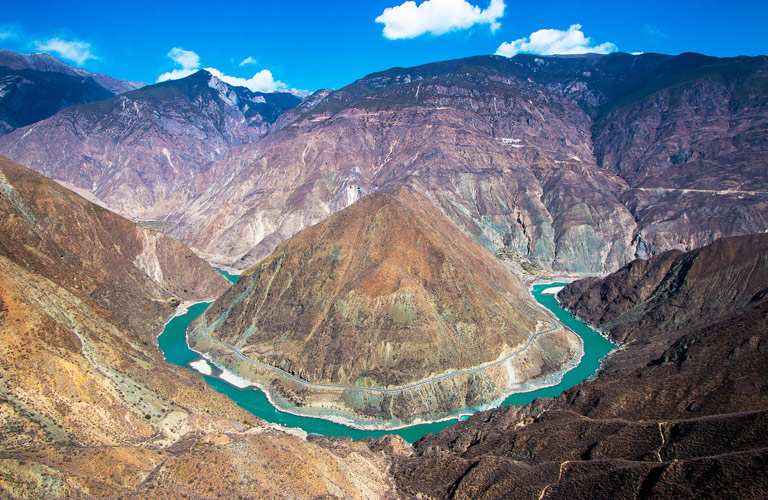
The river originates in the eastern part of the Tibetan Plateau. The Chinese government has declared the Tuotuo tributary as the source of the river. This tributary is located at the base of a glacier, on the west of Geladandong mountain. The source of the Yangtze River is the highest at 5,342 m above sea level.
The upper region of Yangtze
The middle region of the Yangtze river
The middle course of the Yangtze stretches for 1,010 km between the cities of Yibin and Yichang in Sichuan and the Hubei province, respectively. The place experiences hot summers and mild winters, as the high mountains in the west protect the region from the harsh, cold north and west winds. The annual precipitation measures between 1,000 to 1,500 mm, with heavy rainfall occurring in summer.
In this segment, the river crosses the hilly Sichuan province, where the mountains and plateaus connect the highlands of southwestern China with the Qin Mountains. Also located in this area is Chongqing, a major industrial hub and river port. The river’s width here is 300 to 500 metres, and the depth exceeds 30 feet. The river falls 820 feet 250 metres, which is a little more than a foot per mile or 0.2 metres per km of flow.
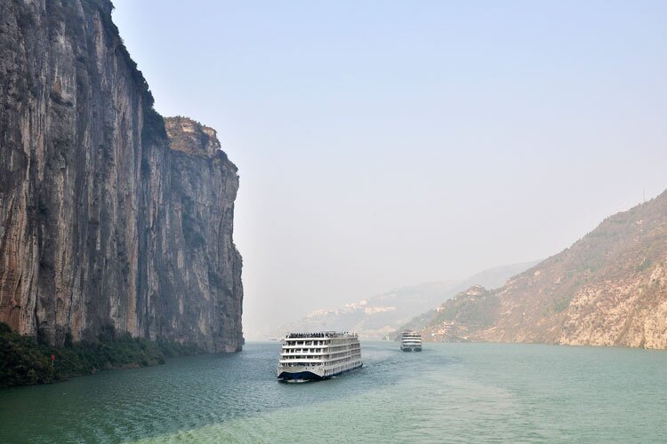
The Yangtze travels a distance of 125 miles through the famous Three Gorges region as it flows from Sichuan to western Hubei. These gorges have thick limestone rocks and steep, high slopes. Prior to the completion of the Three Gorges Dam, The water level in the river of this region was 1,300 to 2,000 feet. However, with the creation of the reservoir, the height of water has diminished fairly significantly.
The three gorges
Qutang, the first gorge on this stretch is about 8 km long. The river there was considered the most dangerous for navigation, as it is extremely narrow and contains rapids and eddies. The second gorge, Wu, stretches for 50 km. It is steep and narrow and has vertical walls of heights up to 2,000 feet above the river. Lastly, Xiling, The last gorge, is located upstream of Yichang and extends for 21 miles. Due to the reservoir, the gorge is rocky and is speckled with cracks and indentations. The depth in the gorge was between 500 and 600 feet, thus making the Yangtze the deepest river in the world.
The lower course of the Yangtze
The lower portion of the Yangtze is on the lowland plains of east-central China. The region has a temperate climate. The people experience hot summers, cool autumns, cold winters and warm springs. Monsoons dominate the weather of the region. Sometimes, a typhoon may occur in summer or winter. Near Yichang, as the Yangtze exits the three gorges dam, it enters an interconnected system of marshes, lakes and multiple river channels. This region lies at elevations below 165 feet 50 metres. Three main tributaries namely, the Yuan, Han and Xiang rivers join the Yangtze in this region. Water levels fluctuate greatly between the flood and low-flow seasons. In addition, the presence of many large lakes, like Lake Hong, Lake Liangzi and Dongting Lake cause considerable changes in water volume. The total area of the lakes is about 6,600 square miles or 17,100 square km. The lakes are mainly used as fisheries.
At the edge of Lake Liangzi, the Yangtze expands to form a large loop. Here, the width of the river is about 800 metres and the depth is greater than 100 feet. Banks are built along the edge for protection against floods. In the south lies the Dongting Lake which shares two canals and four tributaries with the Yangtze River. The surrounding area is used for agriculture and is known as China’s most important rice-producing region.
Further east, the Yangtze flows onto the plain of the Jiangxi province. Here, is the famous Lake Poyang has an average area of about 1,385 square miles or 3,585 square km. Furthermore, The lake receives the Kan River tributary and flows out onto the southern North China Plain. Here, the width of the river is between 900 and 1,800 metres.
The Yangtze delta
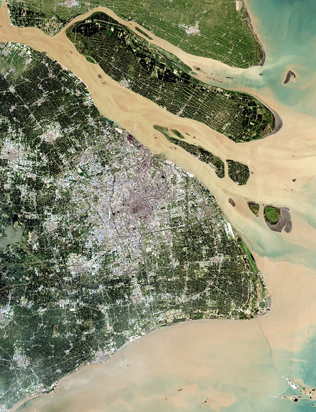
The Yangtze delta consists of a large number of tributaries, lakes, ancient riverbeds, and marshes that are all connected with the main channel of The Yangtze. Lake Tai, stretching across an area of 2,410 square km, is the biggest of the many lakes in the delta. The width of the Yangtze in the delta ranges from 1.6 to 3.2 km. Then, the channel gradually widens and becomes a large estuary, with a width exceeding 80 km. Major cities in the delta include Shangai, Wuxi and Suzhou.
Just before reaching the sea, the Yangtze splits into two streams that drain independently into the sea. The left branch has a width of about 5 to 10 km, while the right one is about 10 to 25 km. Between the two river branches is an island created by large deposits of alluvium at the mouth of the river. The island is called Chongming Island. Here, the depth of the river is between 100 to 130 feet. However, at the mouth of the sea, the depth decreases due to the presence of sandbars.
The Three Gorges Dam
The Three Gorges Dam is the largest hydroelectric power generation station in the world. It was completed in May 2006 and measures 192 meters high and 12.3 km across. The dam is located about 1,610 km to the west of Shanghai, in the Three Gorges Region.
In general, the dam was built to increase shipping capacity, produce electricity, and reduce the occurrence of dangerous floods. However, according to International Rivers, the dam causes its own environmental disasters. Furthermore, its construction also displaced over 12 million people from their homes.
The hydroelectric project became fully operational in 2012. It has the capacity to generate approximately 22,500 megawatts of power. Furthermore, many tributaries of the Yangtze that have significant volume, like the Yalong, Jailing and Min rivers, have great potential to generate hydroelectric power.
Hydrology of Yangtze river
The Yangtze basin is quite well irrigated. The average yearly rainfall amounts to about 43 inches or 1,100 mm. In the lower regions of the river, the precipitation is brought in by the monsoon winds and rainfall primarily occurs in the summer months. However, in the mountains, the precipitation is mainly snow.
Floods are a result of the monsoon rains in the middle as well as lower regions of the basin. These usually begin in March or April and can occur at any time during the next eight months. In May the water level decreases sharply. Then increases again and continues to do so until August. The water level is at its peak in August. The water level then gradually falls to the premonsoon levels, gradually decreasing until February, when the lowest annual level is reached.
The annual range of water-level fluctuations is at an average of about 65 feet. The water level is between 26 and35 feet during years of low water. The impact of water level variation is lessened downstream from the Three Gorges Dam. In the delta, tides exert greatly affect the water level. The daily tidal range is 15 feet near Wusong city, and the yearly range is 20 feet.
Wildlife
The Yangtze River basin covers an area of 448 million acres of varying landscapes from mountains and thick forests to mashy wetlands. Furthermore, it is one of the most biologically diverse regions on Earth. According to the World Wildlife Fund (WWF), the region is home to over 280 species of mammals, 166 species of reptiles, 145 species of amphibians, and 378 species of fish. Some species of fish include the yellow head catfish, copper fish, carp, eel, Chinese puffer fish etc. You can refer to YangtzeRiver.org for more information.
The International Union for Conservation of Nature has included several of the animals in the Yangtze River Basin on their list of threatened and endangered species. The statuses of these animals range from vulnerable or high risk of endangerment to endangered to critically endangers or extremely high risk of extinction. some of them are,
Endangered animals
- Firstly, the giant panda, which lives in the bamboo forests of the Upper Yangtze region, was recently on the endangered list due to the slightly better status of vulnerability. Although the animal has no natural predators, human activity has led to only 1,800 pandas in the wild.

- The Yangtze region is home to the at risk finless porpoise. Only about 1,000 of these creatures exist in the wild. Their endangerment arises from dwindling sources of food and human activity. These porpoises live in the middle and lower parts of the Yangtze River.
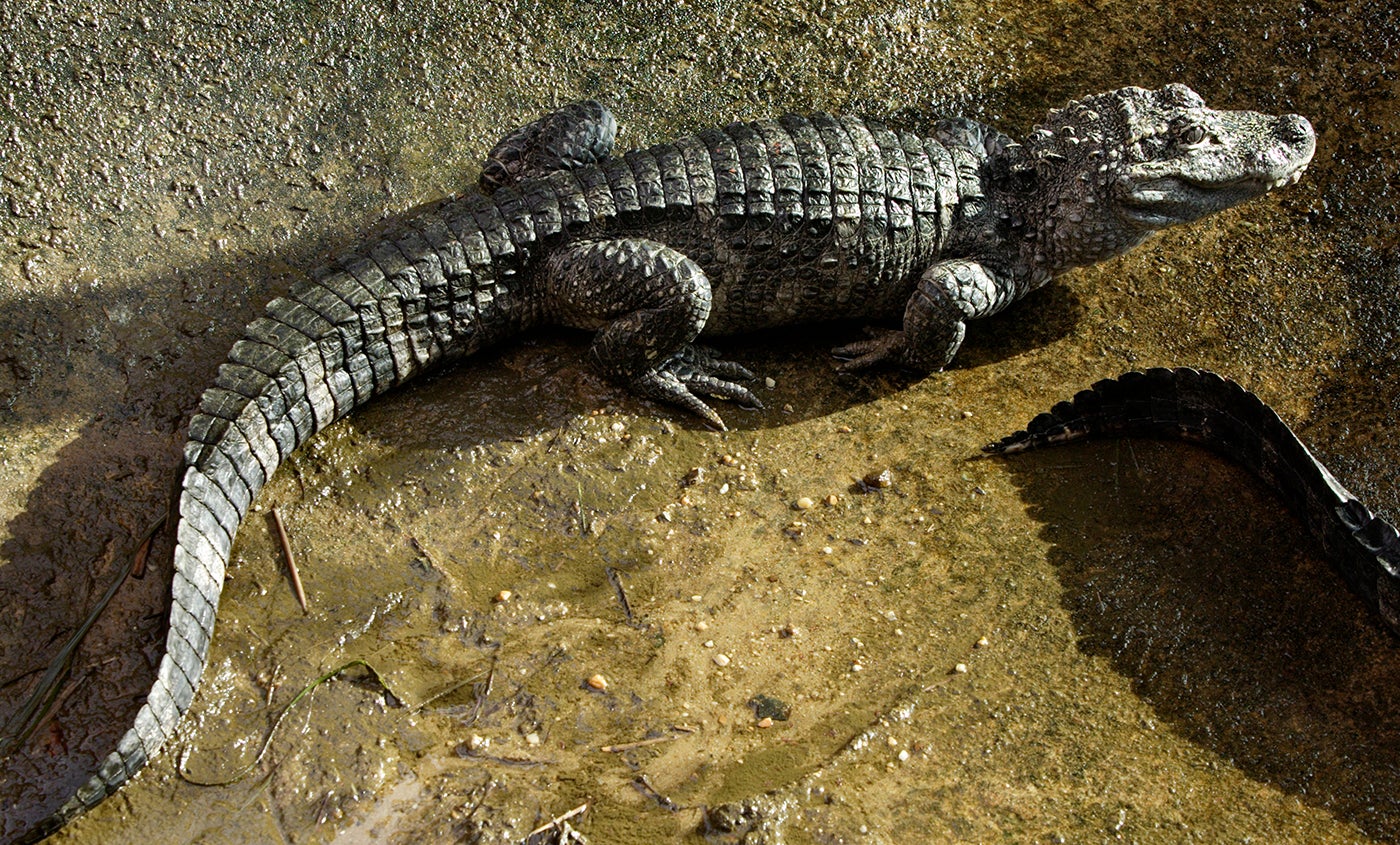
- The critically endangered Chinese alligator, of which there are only 200 in the wild, also live in the lower regions of the river. The Chinese alligator is much smaller than the American species and it grows only to a length of 5 feet or 1.5 m.
- A Yangtze softshell turtle is the largest softshell turtle in the world. It is also a critically endangered species with only three known turtles alive in the world. Two of the three are in captivity in China, and one is in a lake in Vietnam. In July 2016, the efforts to artificially inseminate the last known female was unsuccessful.

Agriculture
The Yangtze River basin is also known as the great granary of China. The soil there is incredibly fertile. Furthermore, the climatic conditions are highly favourable for agriculture. Therefore, the economy of the basin focuses primarily on agriculture.
70 per cent of the grains produced here are rice. Other crops grown include corn, beans, cotton and barley. The growing period ranges from 8 to 11 months, and about two or three crops can be harvested annually.
Additionally, the mild climatic conditions also facilitate sericulture, the production of raw silk by rearing silkworms.
Fisheries
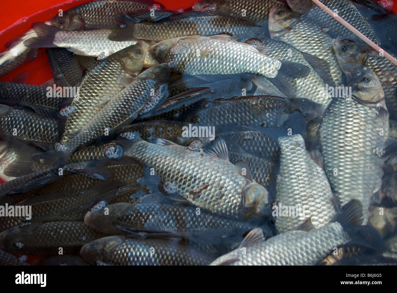
The fishing trade is another major livelihood for most of the population residing in the region. Hundreds of species of aquatic animals are found in rivers, lakes and tributaries. Some commonly available species include bream, carp, Chinese perch, lamprey and gapers (a species of large burrowing clam), lamprey, flatfish and spotted flatfish. The most economically valuable fish are the white and black amur. Further downstream large amounts of roe can be found. These are collected and used for artificial cultivation of fish like white and black amur, carp and flatfish.
Pollution
![Yangtze River plagued by floating garbage[5]- Chinadaily.com.cn](http://www.chinadaily.com.cn/photo/////images/attachement/jpg/site1/20130716/d4bed9d4d220134ef86927.jpg)
Environmental degradation in the Yangtze basin has accelerated due to economic development. The following are the effects observed,
- Pollution levels have risen in the lakes and rivers.
- There is an increase in soil erosion in the middle and upper basins due to overgrazing and the cutting of trees.
- Land reclamation has decreased the area of wetlands and lakes
However, the Three Gorges project has a greater impact than any of the causes mentioned above. The floods caused by the dam has destroyed the most scenically beautiful region in China. Another concern is that the changes made could adversely affect several endangered animal species inhabiting the basin especially including the Chinese alligator, finless porpoise, and the Chinese sturgeon. Additionally, numerous towns and cities have been flooded by the reservoir, forcing the relocation of over one million people. The highly active seismic plates put the region at further risk, especially of catastrophic dam failure. Lastly, the silt free waters downstream of the dam will tend to erode the surrounding banks rather than build them up, thus, leading to deforestation.
FAQs
1. Is Indus the longest river?
The Indus is the longest river in India. It is about 3,600 km in length and passes through India, Pakistan and China. It is the 8th longest river in Asia.
2. Which river is the longer Lena Brahmaputra or Indus?
The river Brahmaputra is longer than Indus.
3. What is the Indus River called in Pakistan?
The Indus river is known as the Sindhu River in Pakistan. The river runs south from the Kailash Parvat in Tibet to the Arabian Sea in Karachi, Pakistan.
4. Who called the Sindhu river Indus?
Between 850 and 600 BCE, there was a change in the sound of *s > h. This passed on from the Persian Empire to the Greeks and then finally, the Romans adopted the name Indus.
5. Which river is known as the Yellow River?
The Huang He River (Yellow River), is the second-largest river in China.
6. What are some of the longest rivers on the planet?
The table below details the 10 longest rivers in the world.
| Rank | River | Location | Approximate Length (miles) |
| 1 | Nile | Africa | 4,180 |
| 2 | Amazon | South America | 3,912 |
| 3 | Mississippi-Missouri-Red Rock | United States | 3,710 |
| 4 | Chang Jiang (Yangtze) | China | 3,602 |
| 5 | Ob | Russia | 3,459 |
| 6 | Huang Ho (Yellow) | China | 2,900 |
| 7 | Yenisei | Russia | 2,800 |
| 8 | Parana | South America | 2,795 |
| 9 | Irtish | Russia | 2,758 |
| 10 | Zaire (Congo) | Congo | 2,716 |
Refer to the document below for further information on these rivers.
7. What are the other long rivers in Asia?
Given below are the longest rivers in Asia.
| River | Countries | Length (km) | |
| 1 | Yangtze | China | 6,300 |
| 2 | Yellow River | China | 5,464 |
| 3 | Mekong | China, Myanmar, Laos, Thailand, Cambodia, Vietnam | 4,909 |
| 4 | Lena | Russia | 4,294 |
| 5 | Irtysh | Mongolia, China, Kazakhstan, Russia | 4,248 |
| 6 | Brahmaputra River | China, India, Bangladesh | 3,848 |
| 7 | Ob | Russia | 3,650 |
| 8 | Indus River | China, India, Pakistan | 3,610 |
| 9 | Yenisey | Mongolia, Russia | 3,487 |
| 10 | Nizhnyaya Tunguska | Russia | 2,989 |
8. What resources does the Yangtze River provide?
The economy of the Yangtze region is solely dependent on agriculture. However, it also contains an abundance of mineral deposits including coal, gold, copper, phosphorus, oil and natural gas. Furthermore, due to the presence of lithium rock salt and rare earth, the Yangtze River is good for pushing forward emerging industries that include new materials, manufacturing and new energy automobiles.
9. Why is tourism in the Yangtze river popular?
Yangtze River is the best witness of ancient China. Though the traditional way of life is disappearing, the beautiful scenery and historical attractions make this region an excellent tourist spot.


